 Home
Home Download
 News
News Mastodon
 Bluesky
 X
X Summary - 17 Years
 Summary - 16 Years
 Summary - 15 Years
 Summary - 13 Years
 Summary - 11 Years
 Summary - 10 Years
 Resources
 Technical Reference
 Scripting Tutorial
 Video Tutorials
 Wiki Pages
 Image Gallery
 Color Presets
 Using libgmic
 G'MIC Online
 Community
 Discussion Forum (Pixls.us)
 GimpChat
 IRC
IRC Report Issue
| Table of Contents ▸ List of Commands ▸ Features Extraction ▸ pointcloud | ◀ plot2value | psnr ▶ |
pointcloud
Arguments:
- _type = { -X:-X-opacity | 0:Binary | 1:Cumulative | 2:Label | 3:Retrieve coordinates },_width,_height>0,_depth>0
Description:
Render a set of point coordinates, as a point cloud in a 1D/2D or 3D binary image(or do the reverse, i.e. retrieve coordinates of non-zero points from a rendered point cloud).
Input point coordinates can be a NxMx1x1, Nx1x1xM or 1xNx1xM image, where N is the number of points,
and M the point coordinates.
If 'M'>3, the 3-to-M components sets the (M-3)-dimensional color at each point.
Parameters width,height and depth are related to the size of the final image :
If set to 0, the size is automatically set along the specified axis.
If set to N>0, the size along the specified axis is N.
If set to N<0, the size along the specified axis is at most N.
Points with coordinates that are negative or higher than specified (width,height,depth)are not plotted.
Default values:
type=0 and max_width=max_height=max_depth=0.
Examples of use:
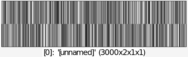
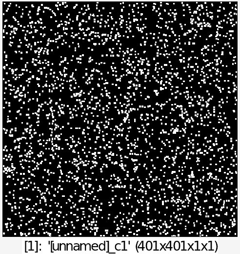
• Example #1
3000,2 rand 0,400 +pointcloud 0 dilate[-1] 3
• Example #2
3000,2 rand 0,400 {w} {w},3 rand[-1] 0,255 append y +pointcloud 0 dilate[-1] 3

